HAZARDS AND DISASTERS
Case Studies 2
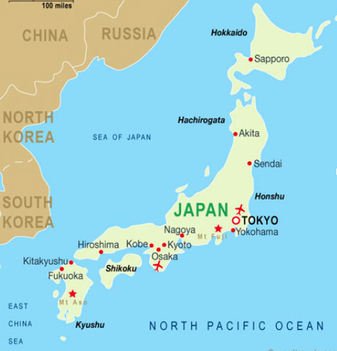
Japan: Tohoku Earthquake and Fukushima Nuclear Disaster
Characteristics: Tohoku Earthquake, Japan, 11th of March 2011
Magnitude & Duration
- Magnitude 9 on Richter Scale
- Hit at 2.46 pmf local time
- Lasted for ca. 6 minutes
- Epicentre is underwater, around 70 km east of the coast of Tohoku peninsula (region)
- Hypocenter is around 30 km under water (quite shallow).
- Nearest major city is Sendai, 130 km from epicentre
- 373 km from Tokyo
- Subduction zone: Pacific plate is sliding under the plate on which Japan lies (not entirely clear). This causes the upper plate to be pressed down, building up a lot of potential energy, which is then released as an earthquake.
- Earthquakes with magnitudes around 6-8 on Richter scale hit Japan a couple of times a year.
- Around Tohoku earthquake there were many foreshocks and aftershocks in the span of around 3 weeks of the earthquake.
- Immediately striking
- Several major foreshocks: 7.2 Magnitude on March 9th
- Hundreds of aftershocks: couple of hours afterwards, of magnitudes 7.4
- Triggers Tsunami waves, since it is by the ocean and under water.
- Extensive and severe structural damage in North Eastern Japan
- Tsunami causes nuclear accidents: meltdown of 3 nuclear reactors
- Displacement of people, deaths, injuries, costs of reconstruciton.
- Japan is an island which lies on the center of a meeting point from the tectonic plates. The mountainous inland area results in a high coastal density.
- 1 minute before earthquake was felt in Tokyo, the Earthquake Early Warning System sent out warnings to millions
- 31 seconds after onset of earthquake the warning was delivered to the public.
Characteristics: Fukushima Daiichi Nuclear Power Plants
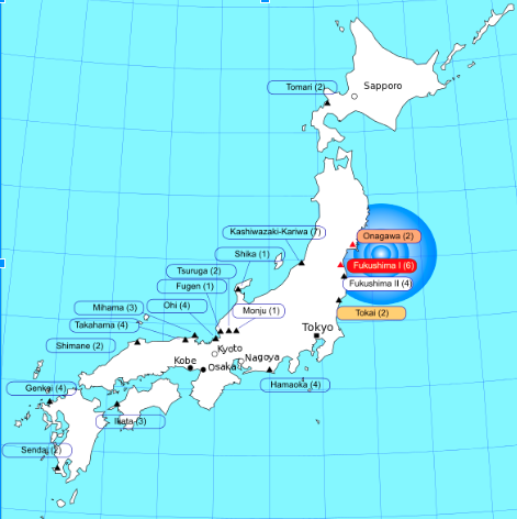
Magnitude & Duration:
- Magnitude 7 on International Nuclear Event Scale
- Caused by the Tsunami after the earthquake
- Highly radioactive materials were released for 4-6 days
- The cores of 3 nuclear reactors melted in three days following the Tsunami
- Radioactive spills in the sea water
Responses and Adjustments
Tohoku earthquake
Long reconstruction: 5 years to rebuild costs $235 billion in damage both in cleaning of the earthquake causing fukushima.
Mid rehabilitation: temporary housing, as the Japanese government are trying to remove evacuees from large shelters, where there have been reports of poor sanitary conditions. Evacuees had moved into 73 percent of the temporary housing available. Evacuation shelters had a shortage of water, food, blankets and bathroom facilities. Dropping temperatures, due to the disruption in electrical and gas lines, caused further problems at shelters.
Short rescue: Japanese government mobilized the Self-Defence Forces many countries helped by sending search and rescue teams to help search for survivors. Shelters were built for the evacuees. Japanese red cross received 1 billion yen in donations. The government in Japan committed to cleaning up the damage from the disaster, an effort forecast to cost a total of ¥1 trillion.
Reduce vulnerability:
Spreading the risk (aid and insurance) : In Japan, scientists had forecast earthquake hazard by watching Earth's crust deform. Researchers are also developing new models to better understand how quickly these historic tsunamis moved, how high they were and perhaps even reveal how big the earthquakes that caused them were.
Fukushima Daiichi nuclear power plant
Long reconstruction: re-evaluation of nuclear japan’s nuclear power programs,
Mid rehabilitation: advised travellers to tokyo, issued potassium iodide tablets as a precautionary measure.
Short rescue: evacuated 140,000 residents, banned/advised travellers to tokyo
Reduce vulnerability:
Land management (zone): Once power was lost, the cooling system shut down. Three of the reactors "quickly overheated, causing meltdowns that eventually led to explosions, which hurled large amounts of radioactive material into the air"
Spreading the risk (aid and insurance): upgraded tsunami warning system, companies such as siemens refused to build nuclear power plants, John Price, said that it "might be 100 years before melting fuel rods can be safely removed from Japan's Fukushima nuclear plant".
Tohoku earthquake (2011)
High Level of Preparedness
The potential for damange due to earthquakes of a given site is associated with considerable uncertainty, eve in a country like Japan. Japan has one of the longest and most well-studied earthquake records in the word.
Despite Japans high building standard and intensive preperation drills, Japan was caught completely off guarddue to the preperation of risk being insanely high. This is due to the following reasons:
Japans civilians have a very high trust in their government, due to the intensive preparation drills, infrastructure, and implemented section on the risk of earthquakes within the education system.
Reduced risk assesment of major disasters including the cohesive disasters - fukushima nuclear disaster, tohoku earthquake and the tsunami.
The fact that 75% of buildings are built and constructed as flexible so as to cause least damage to the buildings.
Fukushima Daiichi nuclear power plan (2011)
Reduced Risk Assesment
According to the above, this suggest that older plants and plants operated by the largest utility companies deserve further scrutiny from researchers and regulators
Considering Japan's high level of preparedness, these disasters are exceptions
Long reconstruction: 5 years to rebuild costs $235 billion in damage both in cleaning of the earthquake causing fukushima.
Mid rehabilitation: temporary housing, as the Japanese government are trying to remove evacuees from large shelters, where there have been reports of poor sanitary conditions. Evacuees had moved into 73 percent of the temporary housing available. Evacuation shelters had a shortage of water, food, blankets and bathroom facilities. Dropping temperatures, due to the disruption in electrical and gas lines, caused further problems at shelters.
Short rescue: Japanese government mobilized the Self-Defence Forces many countries helped by sending search and rescue teams to help search for survivors. Shelters were built for the evacuees. Japanese red cross received 1 billion yen in donations. The government in Japan committed to cleaning up the damage from the disaster, an effort forecast to cost a total of ¥1 trillion.
Reduce vulnerability:
Spreading the risk (aid and insurance) : In Japan, scientists had forecast earthquake hazard by watching Earth's crust deform. Researchers are also developing new models to better understand how quickly these historic tsunamis moved, how high they were and perhaps even reveal how big the earthquakes that caused them were.
Fukushima Daiichi nuclear power plant
Long reconstruction: re-evaluation of nuclear japan’s nuclear power programs,
Mid rehabilitation: advised travellers to tokyo, issued potassium iodide tablets as a precautionary measure.
Short rescue: evacuated 140,000 residents, banned/advised travellers to tokyo
Reduce vulnerability:
Land management (zone): Once power was lost, the cooling system shut down. Three of the reactors "quickly overheated, causing meltdowns that eventually led to explosions, which hurled large amounts of radioactive material into the air"
Spreading the risk (aid and insurance): upgraded tsunami warning system, companies such as siemens refused to build nuclear power plants, John Price, said that it "might be 100 years before melting fuel rods can be safely removed from Japan's Fukushima nuclear plant".
Tohoku earthquake (2011)
High Level of Preparedness
The potential for damange due to earthquakes of a given site is associated with considerable uncertainty, eve in a country like Japan. Japan has one of the longest and most well-studied earthquake records in the word.
Despite Japans high building standard and intensive preperation drills, Japan was caught completely off guarddue to the preperation of risk being insanely high. This is due to the following reasons:
Japans civilians have a very high trust in their government, due to the intensive preparation drills, infrastructure, and implemented section on the risk of earthquakes within the education system.
Reduced risk assesment of major disasters including the cohesive disasters - fukushima nuclear disaster, tohoku earthquake and the tsunami.
The fact that 75% of buildings are built and constructed as flexible so as to cause least damage to the buildings.
Fukushima Daiichi nuclear power plan (2011)
Reduced Risk Assesment
- the vulnerability of nuclear power plants to a disaster like the one that occurred at Fukushimai.
- Examination of Japanese nuclear plants affected by the earthquake and tsunami on March 11, 2011 shows that three variables were crucial at the early stages of the crisis:
- plant elevation
- sea wall elevation,
- location and status of backup generators.
- Higher elevations for these variables, or waterproof protection of backup generators, could have mitigated or prevented the disaster.
- Japanese plants were relatively unprotected against potential inundation in international comparison, but there was considerable variation for power plants within and outside of Japan.
According to the above, this suggest that older plants and plants operated by the largest utility companies deserve further scrutiny from researchers and regulators
Considering Japan's high level of preparedness, these disasters are exceptions
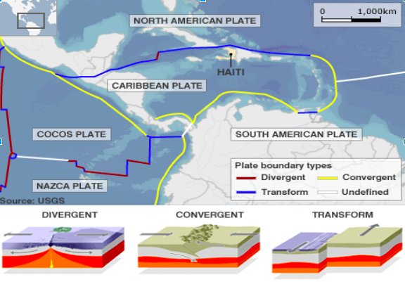
2010 Haiti Earthquake
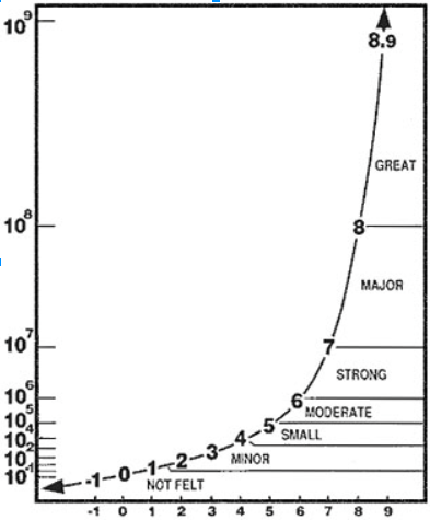
The richter scale
|
Summary of hazard event: The 7.0 magnitude quake that rocked Haiti on Jan 12, 2010 was the country’s most powerful in more than 200 years. More than 200,000 people were killed, and 1.5 million people were left homeless.
Vulnerability:
Risk Assessment:
Responses:
|
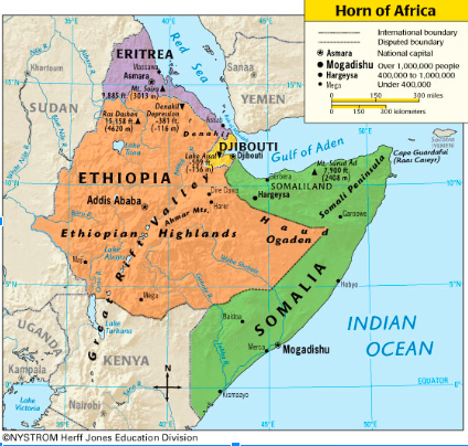
Drought in Horn of Africa (specifically Somalia)
|
Summary of hazard event:
Two seasons of weak seasonal rains (2009 and 2010) causing famine in 2011. The worst drought in 60 years. Affected over 13 million people in the Horn of Africa (Ethiopia, Somalia, Djibouti and Kenya). Vulnerability:
Impacts/Effects:
Short term: Red Cross
Mid term:
|
|
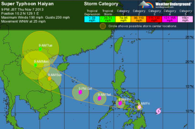
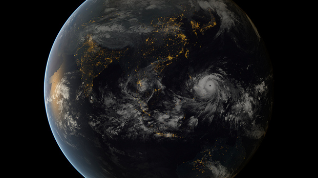
Typhoon Haiyan, 2013
Characteristics of hazard (s) in the area : The Philippines
Vulnerability of Communities: Vulnerable to typhoons because
Typhoon Haiyan
Prediction of hurricanes
Preparedness:
- suffered from high number of deadly typhoons, earthquakes, volcano eruptions and other natural disasters.
- is located along Ring of Fire: large Pacific Ocean region where many of Earth’s volcanic eruptions and earthquakes occur.
- is area most exposed to tropical storms in the world.
Vulnerability of Communities: Vulnerable to typhoons because
- above Equator
- tropical weather, making the ocean warmer
Typhoon Haiyan
- A typhoon is a tropical storm which forms in the Pacific ocean, feeds on warm water (>26 degrees Celsius). Because heat has higher pressure than cold, warm air is pus forcing the cold wind to drop down and reheat.
- This is the coriolis effect.
- Best seasons for typhoons are between July and November (water is warmer)
- Typhoons only form between latitude 5 and 30, always above the Equator.
- They cannot survive on land more than a few hours, because there is no water on land.
- makes small islands (Philippines,...) very vulnerable.
- Rated in categories (1 to 5 where 5 has winds > 157 mph)
- Start/End: November 2, 2013 – November 11, 2013
- Philippines latitude location: 13˚
- Magnitude: Category 5, Super Typhoon
- Top wind speed = 195 mph
- Average wind speed = 145mph
- Areas affected: central Philippines but crossed South-Vietnam and South China as it dissipated.
- ± 86,000 inhabitants affected.
- Damage costs:
- Storms over all estimated cost to the Philippines - $14 billion
- $225 million in Agricultural Damage
http://www.washingtonpost.com/blogs/worldviews/wp/2013/11/12/47-statistics-that-explain-typhoon-haiyan/
Prediction of hurricanes
- possible several days in advance but hard to accurately predict the intensity + area it will affect
- no house evacuation
- lack of communication system
Preparedness:
- Poverty → The Philippines ranked 165th in the world for GDP
- low infrastructure because government has very few resources
- More than 100 different languages are spoken in the Philippines “it makes it tougher for the central government to push through big infrastructure development, or to organize a national response once disaster strikes”
- High crime rates caused loss of control of the government right before the storm hit
- international aid (including UNDP: United Nations Development Programme)
- strengthened solidarity between the Filipino’s
- improved radio communications system
- able to limit ravages of following typhoon (Typhoon Hagupit) : “Without such vital information and an emergency communication system, the city would not have been able to so effectively coordinate typhoon Hagupit preparedness and response activities,” said Mr. Amano, a star rescuer with the City Disaster Risk Reduction and Management Office (CDRRMO).
|
|
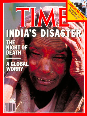
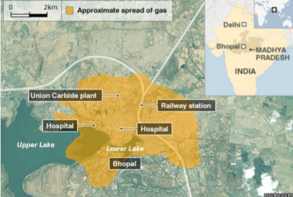
Bhopal Industrial Disaster, India, 1984
Worst industrial disaster in India’s history
On the night of December 2nd - 3rd 1984, the Union Carbide Corporation owned plant: Union Carbide India Limited Methyl isocyanate (MIC) plant located in Bhopal, Madhya Pradesh, India exploded.The MIC spread to the slums surrounding the plant, exposing over 500,000 people to the highly toxic gas.
Safety systems were not taken care of and turned off in order to save money.
Clusters of slums had increased around the immediate vicinity of the Bhopal plant. Poor infrastructure. Bhopal union carbide plant located in an area of high density (more than 200 people per hectare)
Poor environmental regulations in India.
Exposure to the gas can cause
- Coughing
- Chest Pain
- Dyspnea
- Asthma
- Eye, nose, throat irritation
- Skin damage
- Fetal mutations and stillbirths.
Vulnerability: very vulnerable due to bad infrastructure.
High population density → affecting a greater amount of people
unprepared
condition of plant → badly maintained, deteriorating pipes, low environmental regulation caused the condition of the plant to deteriorate, not cleaned properly.
Response
Aftermath
On the night of December 2nd - 3rd 1984, the Union Carbide Corporation owned plant: Union Carbide India Limited Methyl isocyanate (MIC) plant located in Bhopal, Madhya Pradesh, India exploded.The MIC spread to the slums surrounding the plant, exposing over 500,000 people to the highly toxic gas.
Safety systems were not taken care of and turned off in order to save money.
Clusters of slums had increased around the immediate vicinity of the Bhopal plant. Poor infrastructure. Bhopal union carbide plant located in an area of high density (more than 200 people per hectare)
Poor environmental regulations in India.
Exposure to the gas can cause
- Coughing
- Chest Pain
- Dyspnea
- Asthma
- Eye, nose, throat irritation
- Skin damage
- Fetal mutations and stillbirths.
Vulnerability: very vulnerable due to bad infrastructure.
High population density → affecting a greater amount of people
unprepared
condition of plant → badly maintained, deteriorating pipes, low environmental regulation caused the condition of the plant to deteriorate, not cleaned properly.
Response
- UCC claims sabotage vs. Bhopal Government claims corporate negligence
- Indian Government demanded USD 3.3 billion - UCC ended paying USD 470 million
- Indian Government “requested UCC and its subsidiary UCIL "voluntarily" fund a hospital in Bhopal, at an estimated $17 million, to specifically treat victims of the Bhopal disaster. The company agreed to this.”
- 1994 - UCC sells UCIL to Eveready Industries India Limited (EIIL)
- EIIL stopped clean up when control of the plant site was given to the government of Madhya Pradesh in 1998
Aftermath
- Around 25.000 people have died due to the disaster
- Effects of the accident are still felt up to this date → children born disabled after the incident
- 93% of injured regarded as short term injured even though there are still many cases of gas related diseases found even today
|
|
Hurrican Katrina, USA
Description of hazard event/ disaster
Risk assessment
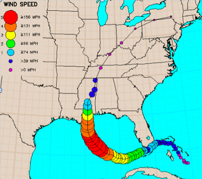
- August 23, 2005
- Intensified when reaching the Gulf of Mexico, growing from category 3 to 5
- Hurricane ended up as a level 3 when reaching New Orleans (saffir-simpson scale)
- Died shortly after reaching land.
- Unusually warm water increased wind speeds (above 26 degrees celsius)
Risk assessment
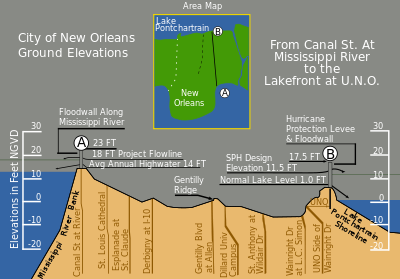
- About half the city lies above sea level- increased risk
- Lake and river level: 10 feet
- Lowest land level: >0 feet (st. Anthony at Wildair drive)
- Average elevation is about six feet below sea level, surrounded by water.
|
Areas affected between Mississippi river and lake Pontchartrain :
|
|
Response
- Before Katrina hit: first ever mandatory evacuation order of the city
- Superdome: a stadium located on relatively high ground near downtown
- served as a shelter for people who could not leave the city.
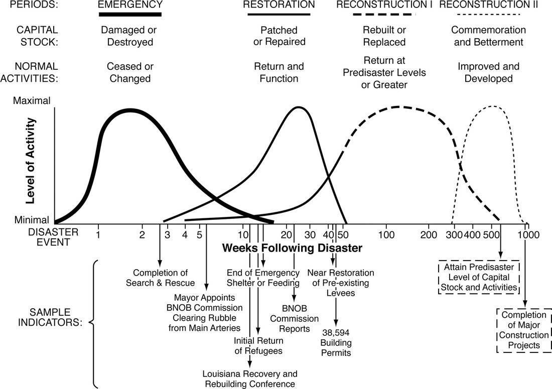
- Search and rescue completed 3 weeks after disaster event
- Main evacuations after hurricane hit- failure of response
- killed nearly 2,000 people and affected some 90,000 square miles of the United States. Hundreds of thousands of evacuees scattered far and wide
- Clearing rubble & restoration months after disaster
- Trust in government and high level of technology decrease risk perception
|
Adjustment
A few links for further reading http://understandingkatrina.ssrc.org/Cutter/ http://www.nhc.noaa.gov/archive/2005/pub/al122005.public.023.shtml http://www.npr.org/2012/11/03/164224394/lessons-from-katrina-boost-femas-sandy-response |
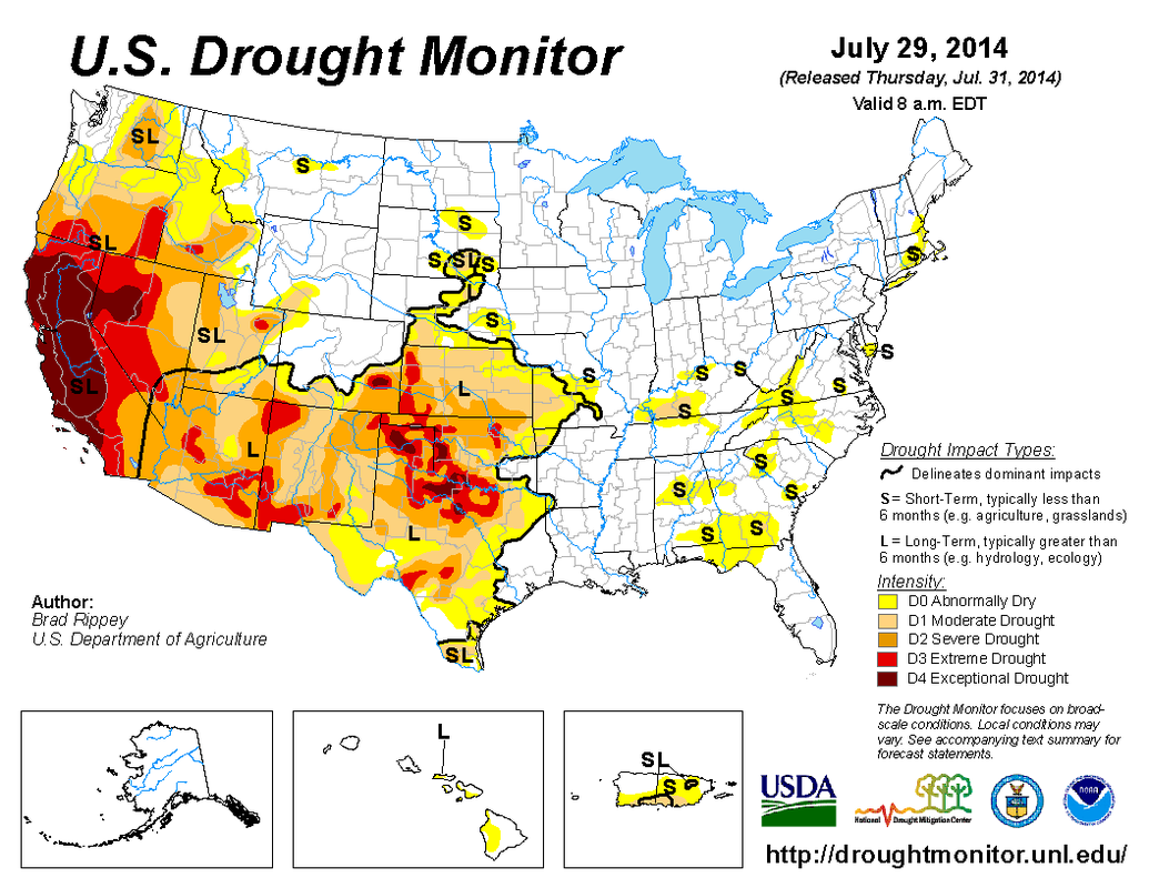
California Drought

Description of hazard event/ disaster
Risk assessment
Adjustment
A few links for further reading:
http://www.nationalgeographic.com/west-snow-fail/
https://www.youtube.com/watch?v=rHWHuP91c7Y
http://ca.gov/drought/
- Cloudless skies, high pressure around California
- Covering 100% of California
- 3rd year of drought: 2012-now
- US drought monitor: California has exceptional drought (category D4)
Risk assessment
- Central Valley Agriculture is mainly impacted: 300 different crops, 30% of US agricultural produce, using 2% of land
- Impact on water resources: snowpack
- Reservoirs: San Francisco: Yosemite, Los Angeles: Mono Lake
- Economy is expected to lose a total of $2.2 billion: $203 million in lost dairy and other livestock value, plus additional groundwater pumping costs of $454 million.
- Pushing conservation, increasing efficiency, investing in new infrastructure to safely recycle used water, and increasing storage capacity.
- Lompico: Linking to a Bigger Neighbor
- Kern County: Reversing the Aqueduct's Flow
- Fair Oaks: Caring for the River
- Montecito: Buying Water From Farmers
- Not many people are impacted, no radical changes- decreases risk perception
Adjustment
- Drought is still ongoing
A few links for further reading:
http://www.nationalgeographic.com/west-snow-fail/
https://www.youtube.com/watch?v=rHWHuP91c7Y
http://ca.gov/drought/